

FEDERAL FUNDS TARGET AMERICAN LANDOWNERS They Called It “Voluntary”
How Federal Funding, State Enforcement, and Trust Land Policy Are Converging in Washington State


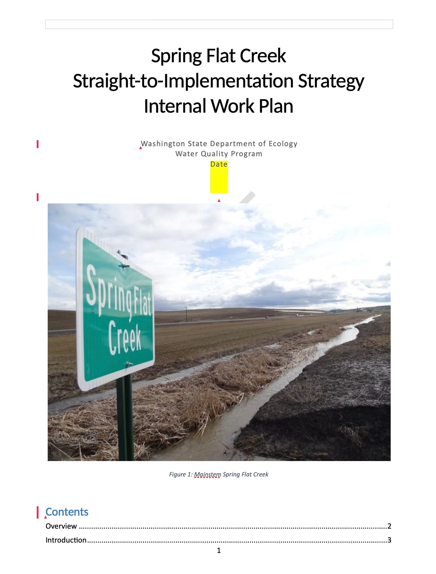
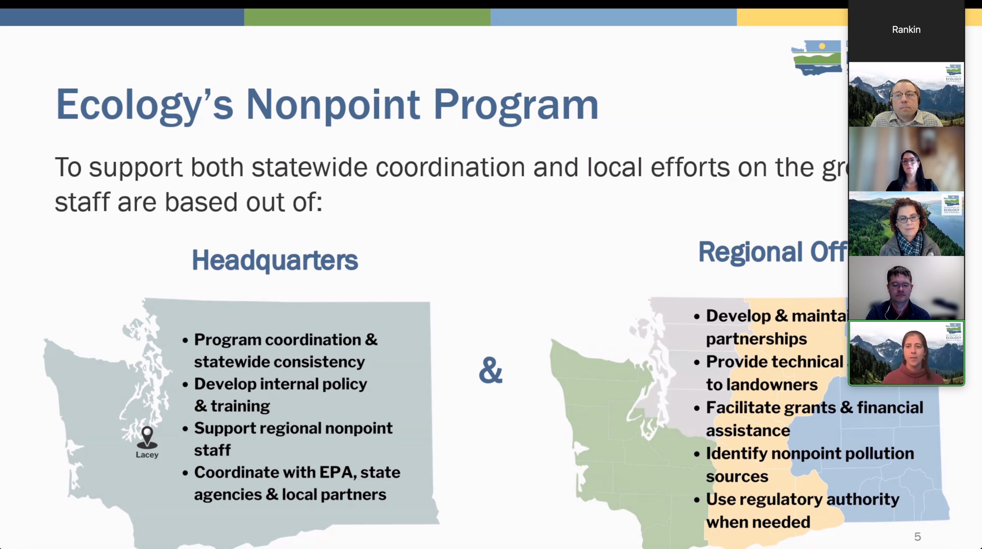
In Whitman County, Washington, Spring Flat Creek — a small intermittent tributary — has become the focal point of a much larger question. Not about one farmer. Not about one watershed. But about a system where federal funding, state enforcement, and trust land policy operate simultaneously on the same land.

When federal law, federal funding, and state enforcement authority converge before a completed TMDL allocation, are planning, reporting, and sequencing fully aligned?
When these systems align, productive land can be functionally removed from use—without a single formal taking.
Each piece is legal. Each serves a purpose. But when they converge, the question becomes: Are they working in alignment — or simply in parallel? That question is administrative. And it is reviewable.
This analysis does not challenge the legality of individual programs, but examines how their combined application may produce outcomes not fully evaluated in isolation. In practice, this can mean acres are converted to buffers, removed from production, or restricted—based on modeled assumptions rather than measured data.
The Framework: Moving Before the Math Is Finished
Spring Flat Creek is listed as Category 5 impaired under the Clean Water Act. Federal law requires a Total Maximum Daily Load (TMDL) — the “pollution budget” that quantifies sources and sets measurable reduction targets.
It is a question of how a statewide implementation model operates within federally overseen programs.
Washington instead uses a “Straight-to-Implementation” (STI) model. The state’s own STI planning document states: “While the STI is being implemented, the requirement to develop a TMDL remains.” Implementation proceeds under §319 funding eligibility while the federal planning obligation stays on the books.
Washington’s own STI planning document states plainly:
“Total Maximum Daily Loads (TMDLs) are required for all waterbodies that do not meet water quality standards.”
The document continues:
“Developing TMDLs can be long, labor-intensive efforts… The purpose of a straight-to-implementation (STI) effort is to get to cleaner water faster.”
And critically:
“While the STI is being implemented, the requirement to develop a TMDL remains.”
This language establishes the sequencing tension.
But implementation sequencing does not eliminate the requirement to develop, prioritize, and publish allocation modeling within a TMDL framework.
What the STI document does not specify for Spring Flat Creek:
A defined TMDL completion timeline
A watershed-specific prioritization schedule
A measurable trigger for transition from STI to finalized allocation modeling
Early action is permissible.
Indefinite sequencing without transparent scheduling invites institutional review.
What Farmers Are Actually Receiving
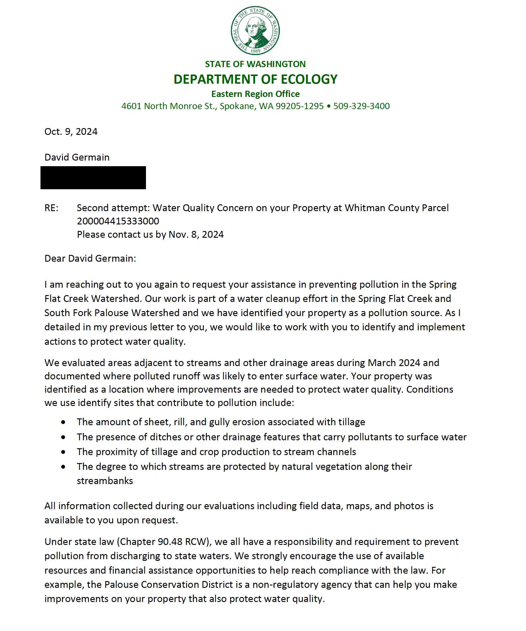
In 2024, landowners received nearly identical letters from the Department of Ecology: “We identified your property as a pollution source.” The basis? Visual indicators: sheet and rill erosion, bare soil, livestock access, tillage near waterways, reduced riparian vegetation.
Absent: numeric sampling, lab data, or parcel-specific pollutant loads.
The program follows a defined escalation: technical assistance → second attempt → warning letter → administrative order and potential penalties. Ecology describes it as “voluntary first.”
Follow-Up Letter (Yenna):
“We identified your property as a pollution source.”
The identification is described as:
“documented where polluted runoff was likely to enter surface water.”
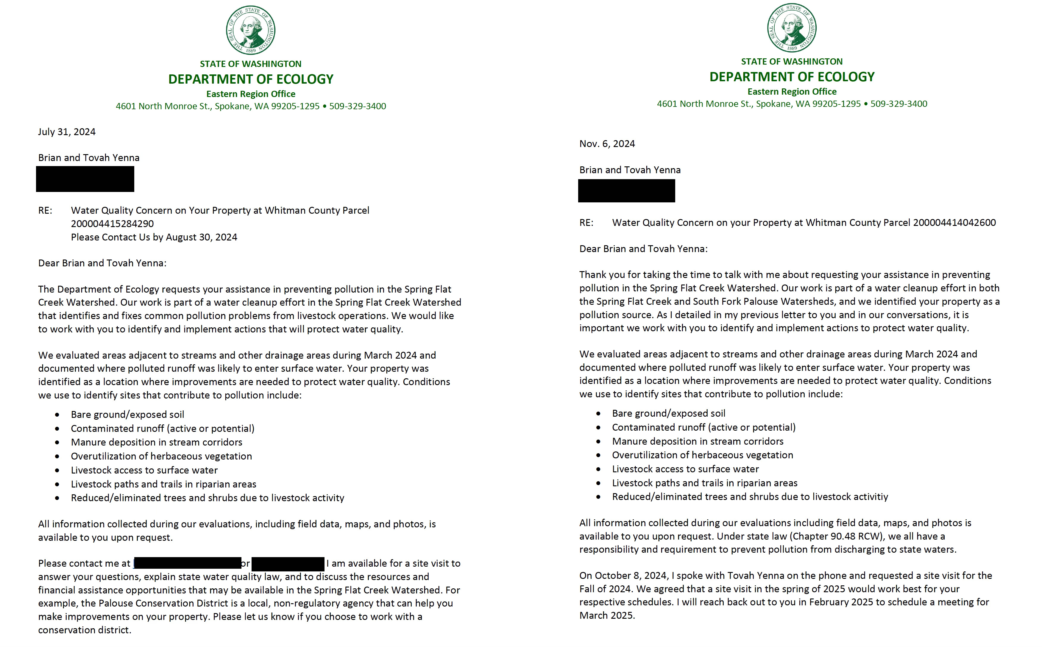
Cited conditions include:
Sheet and rill erosion
Tillage proximity to streams
Bare ground/exposed soil
Livestock access
Reduced riparian vegetation
Notably absent from the letters:
Numeric sediment sampling
Temperature exceedance data
Dissolved oxygen readings
Modeled pollutant load comparisons
TMDL allocation exceedance references
Under RCW 90.48, Washington may act where there is substantial potential for discharge. That authority is independent of federal TMDL timing. The state does not need to wait for numeric allocation modeling to require corrective measures.
That distinction matters.
Visual indicators may satisfy state-law enforcement thresholds.
However, when corrective measures implemented through such determinations intersect with federally conditioned §319 funding and annual load-reduction reporting to EPA, the evidentiary bridge becomes relevant to federal transparency.
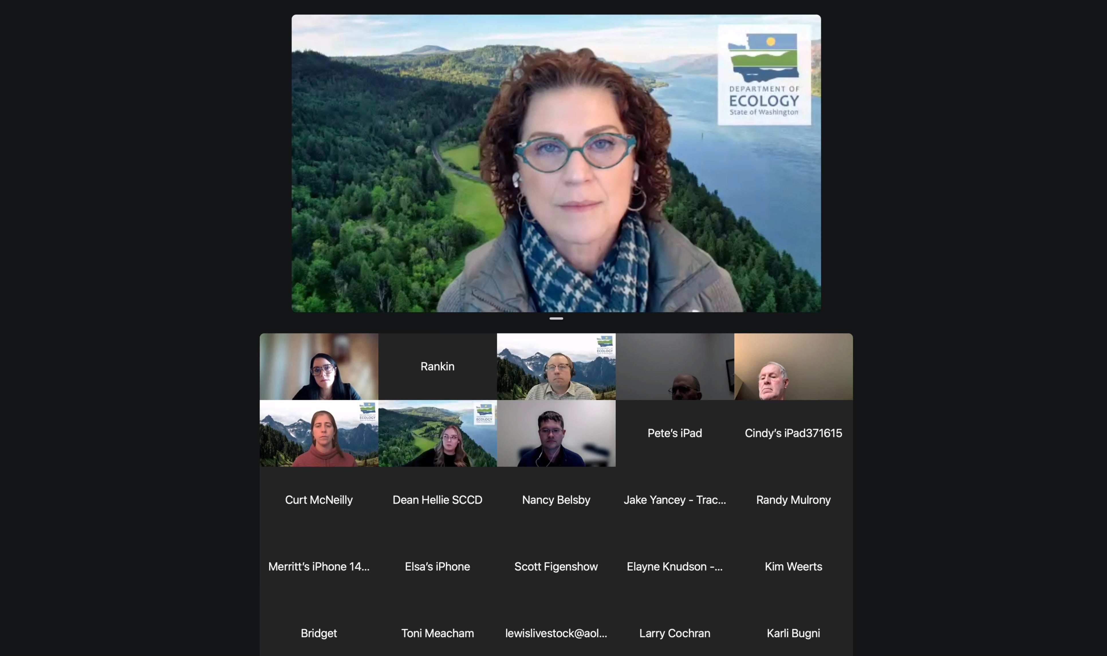
During the March 11, 2026 Washington Cattlemen’s Association town hall, nonpoint program supervisor Ben Rau confirmed that field staff continue to rely on precisely these visual indicators:
“The primary thing when we’re doing those watershed evaluations and what we’re looking for to identify sources of pollution are those site conditions… the Livestock and Water Quality Focus Sheet and then the Landowner Site Assessment Tool. And those are the same things that then we also use, our field staff use to identify sources.”
The compliance question is not whether Washington can act.
The question is how site-level visual determinations translate into quantifiable load-reduction figures reported to federal authorities.
The Voluntary Framework and the Enforcement Backstop
Throughout the meeting, Ecology repeatedly emphasized that its approach is “voluntary first,” with enforcement described as a last resort.
However, agency officials also confirmed the existence of a clear escalation pathway. Nonpoint program supervisor Ben Rao described the sequence this way:
“We do have a gradual escalation process. So if the problem isn’t being addressed, we’ll give multiple times trying to talk with you on that education outreach technical assistance route. And then at a certain point, we escalate to a warning letter and then it would go to an order.”
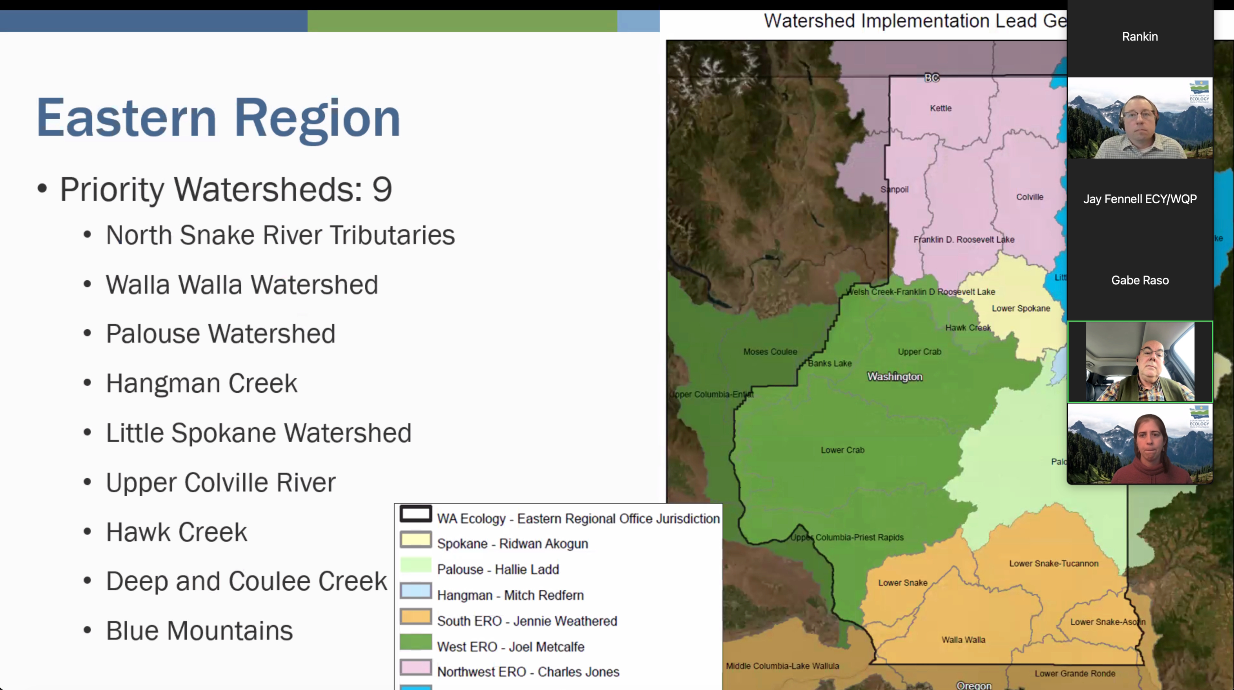
Eastern Region watershed unit supervisor Mitch Redfern provided concrete numbers from the Hangman watershed (a priority watershed using the same framework):
“We’ve prioritized 108 sites now that we’ve been actively working with individually on plans and out of those 108 sites, we’ve issued regulatory enforcement actions on five.”
When asked directly about the risk of another “King Ranch situation” for landowners who decline the voluntary route, Mitch added:
“We really try really hard to find an agreement on a plan… I hate getting to that point because it really bogs us down. I’d much rather meet on a site and come up with a plan that works for everybody and we can get funded.”
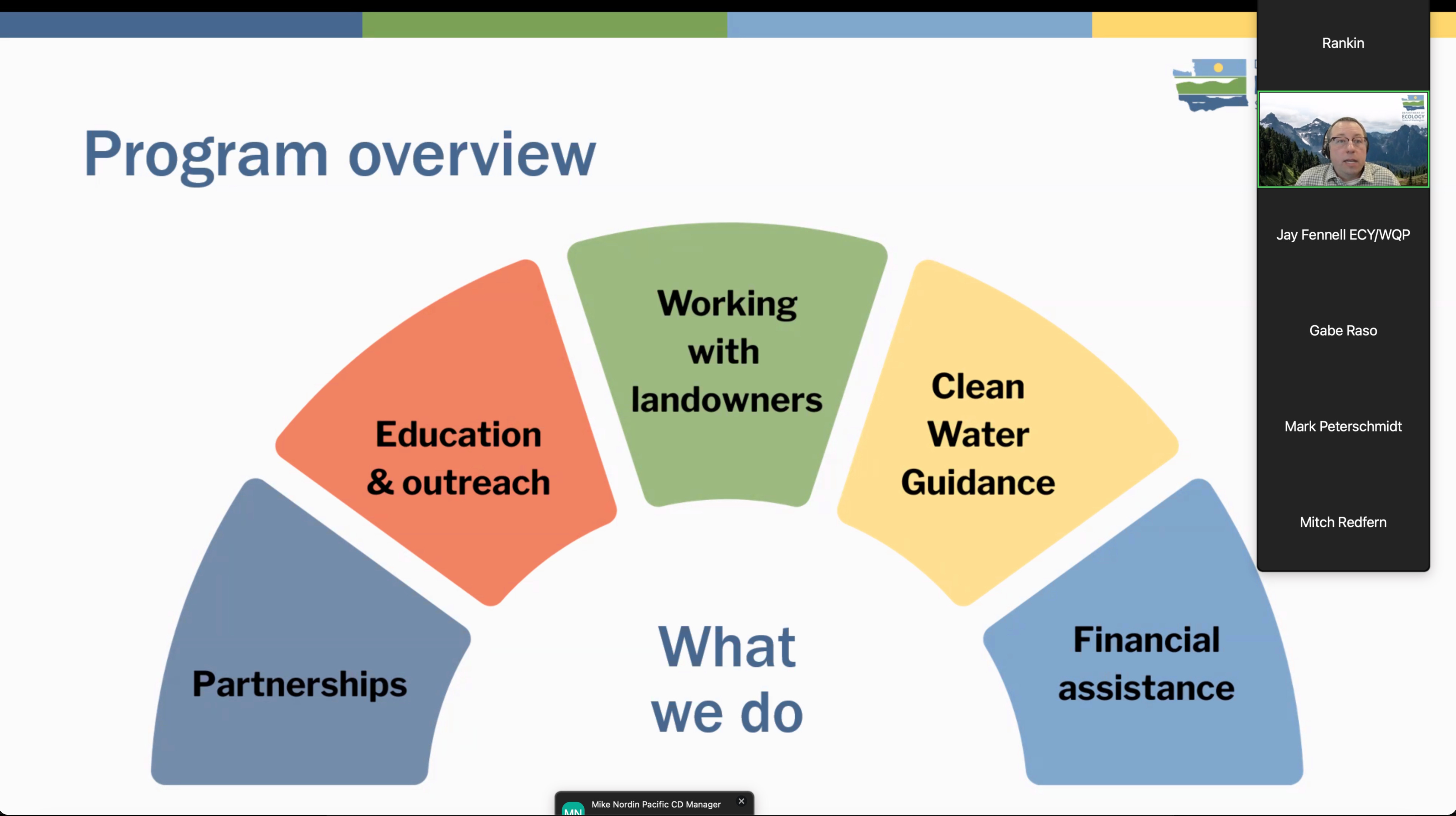
Technical assistance, cost-share funding, and cooperative engagement were presented as the primary tools of the program.
However, the agency also confirmed the existence of an escalation pathway:
Initial outreach
Follow-up technical assistance
Warning letters
Potential administrative orders or penalties under state law
This structure is consistent with the enforcement pipeline observed in Spring Flat Creek.
The distinction between voluntary participation and compelled compliance is not binary.
It is sequential.
Participation may begin as voluntary.
It may become mandatory if concerns remain unresolved.
That sequencing is central to understanding how implementation occurs on the ground—and how federally supported voluntary programs interact with state enforcement authority under RCW 90.48.
Land Use Changes: When Buffers Become Boundaries
In at least one documented case, landowners received mapped requirements: a 60-foot buffer along Spring Flat Creek and a 30-foot buffer along a tributary — removing approximately 12 acres of productive farmland. These buffers are tied to funding eligibility and enforcement expectations.
The STI document clarifies:
“35-foot buffers were used… merely for simplicity… 35-foot buffers are not the recommended buffer widths.”
EPA permits modeled load reductions for nonpoint source pollution. Nationwide, agricultural runoff is typically addressed through proxy modeling rather than parcel-by-parcel laboratory measurement.
The issue here is not the use of modeling.
It is the interaction between:
Numeric buffer assumptions
Enforcement escalation referencing potential administrative orders
Acreage conversion tied to corrective expectations
Federal reporting of modeled load reductions
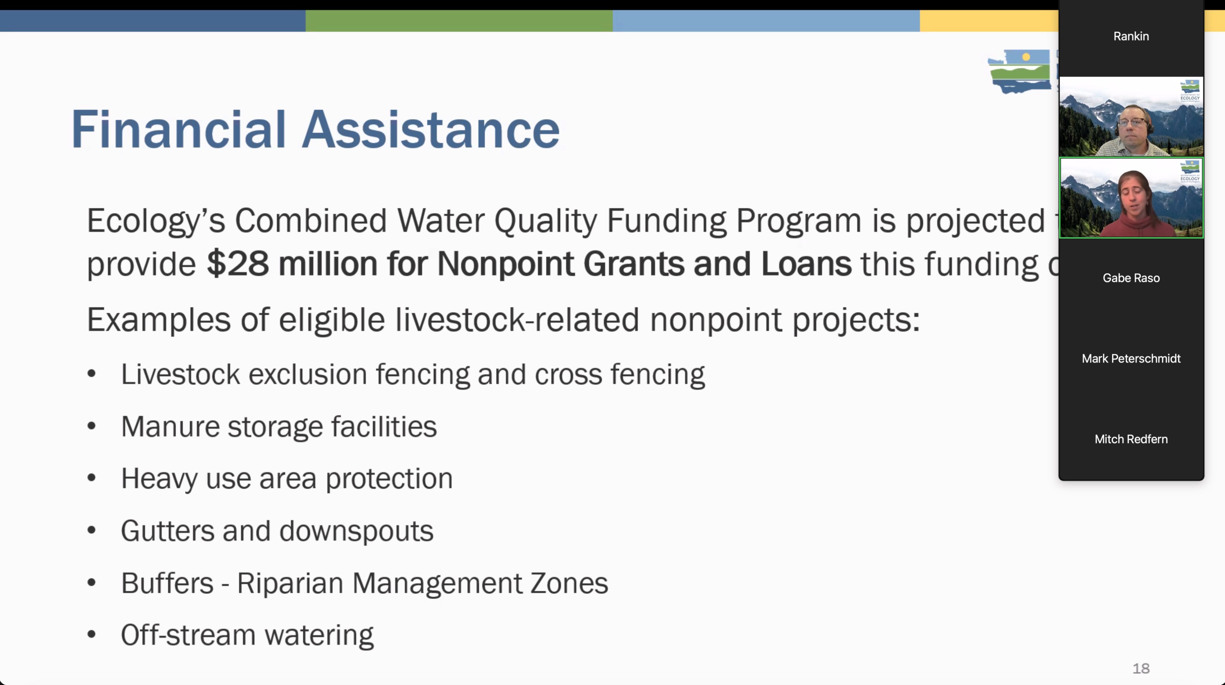
Ecology’s March 2026 presentation slides explicitly list “Buffers – Riparian Management Zones” as an eligible project under the agency’s Combined Water Quality Funding Program, projected to provide $28 million for nonpoint grants and loans. The slides also highlight additional funding sources (WSCC, NRCS, FSA, etc.) that staff “strive to connect landowners with” for BMP implementation.
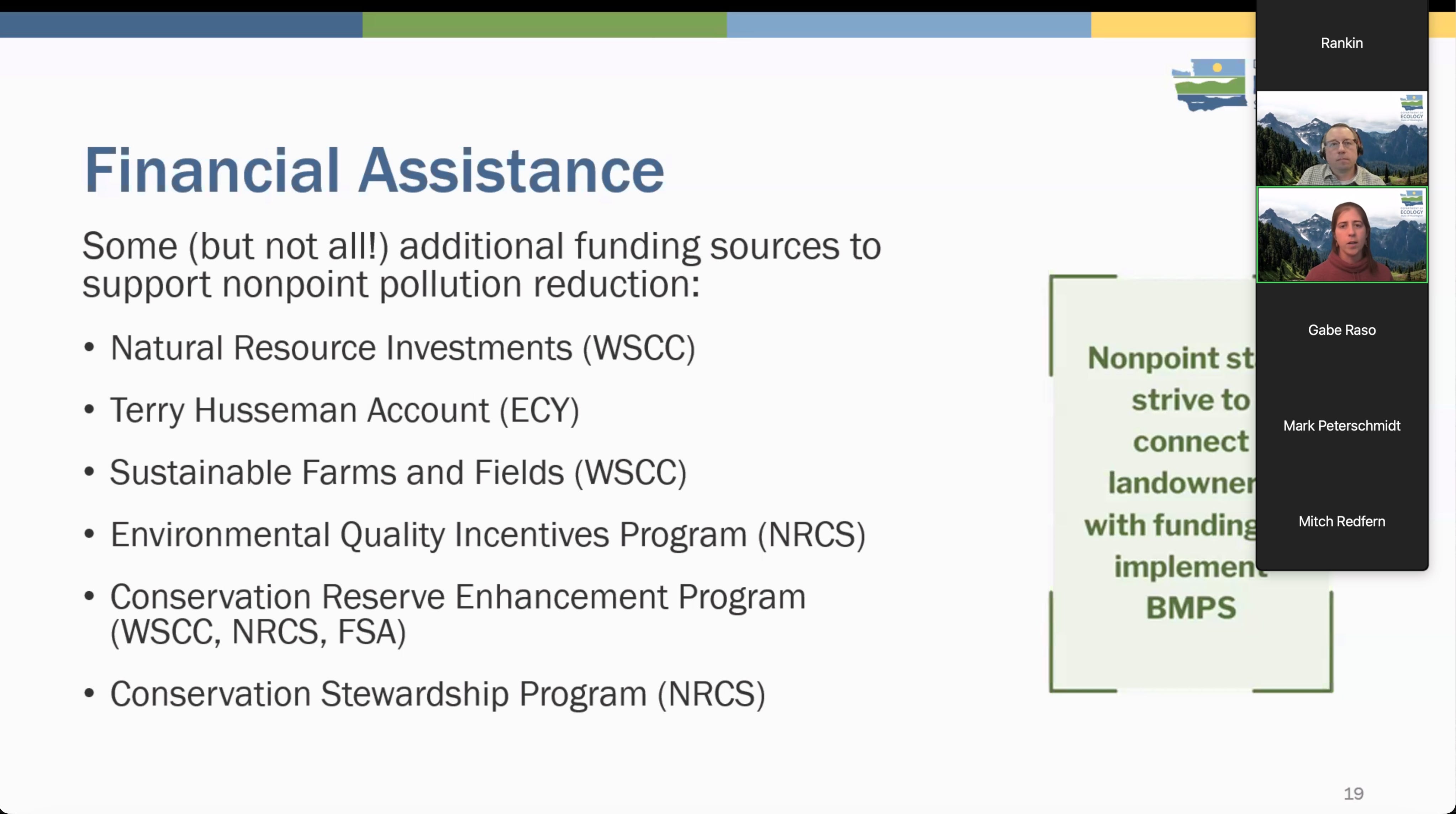
The new Voluntary Clean Water Guidance for Agriculture—final chapters submitted to EPA and in the final publication stage as of the March 11 town hall—plays a central role in these recommendations. Statewide nonpoint policy lead Hannah Coe and Ben Rao explained its function and its tie to funding:
“The role of the voluntary clean water guidance is to provide site-specific BMP recommendations that provide certainty to agriculture producers that if you implement those BMP recommendations that they support clean water and achieve compliance with state water quality laws… When an operator implements those suites of BMPs consistent with the guidance recommendations, we’ll presume that water quality is being adequately protected… We’ll use it to update our funding guidelines and align our funding program with the recommendations found in the guidance.”
If numeric buffer widths function as de facto compliance thresholds connected to enforcement authority — yet derive from internal guidance rather than formally promulgated rule — clarification of authority becomes appropriate.
This is an administrative question, not a political one.
Follow the Federal Money
Through Clean Water Act §319, federal funds support the very conservation practices (riparian buffers, restoration) being implemented. Outcomes are reported to EPA as modeled load reductions — not direct parcel-level measurements. Palouse Conservation District grant documents show 19.11 acres of buffers tied directly to federal reporting.
Grant documentation from the Palouse Conservation District confirms that federal §319 funds are integrated into watershed implementation efforts, with annual sediment and nutrient load reductions reported to EPA.
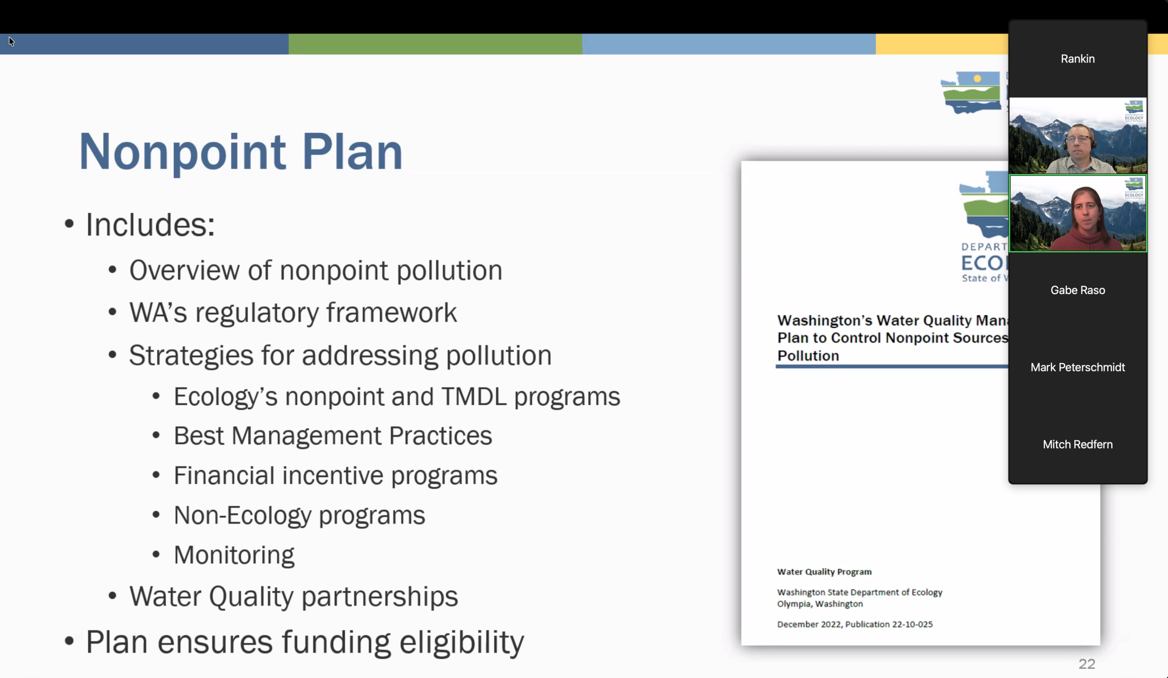
Ecology’s own March 2026 slides state that the updated Nonpoint Plan “ensures funding eligibility” and is required by EPA to maintain access to federal grant and loan dollars. The slides further show how nonpoint staff actively connect landowners to these funds — including for the very riparian buffers being implemented through the STI model and enforcement pipeline.
EPA allows modeled reductions in nonpoint source programs. The oversight question is therefore not whether modeling is permitted.
It is whether modeling assumptions and reported reductions are:
Traceable to documented site-specific conditions
Consistent with Clean Water Act planning sequencing
Transparent in methodology and allocation basis
If enforcement letters rely on visual indicators of potential runoff, but federal reports rely on generalized buffer models to quantify reductions, documentation alignment becomes central.
This creates a “methodological bridge” between site-level conditions and federally reported outcomes.
The methodological bridge is this: visual site conditions → enforcement → BMP installation → modeled reductions → federal reporting. EPA permits modeling, but the oversight question is whether those reductions are traceable, verifiable, and aligned with federal planning requirements when enforcement is also in play.
Grant documentation from the Palouse Conservation District provides a detailed view into how water quality improvements are quantified and reported within Washington’s nonpoint source framework.
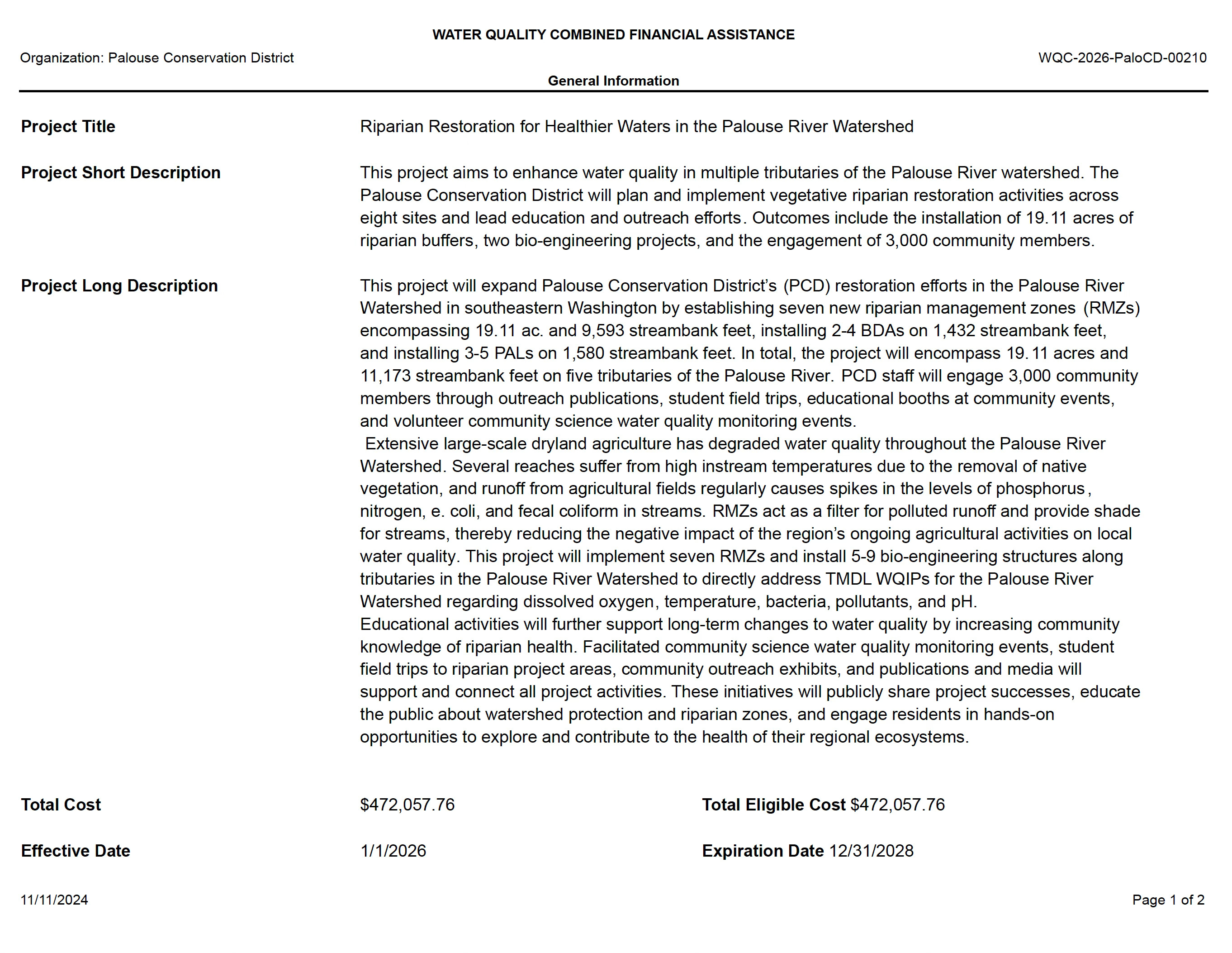
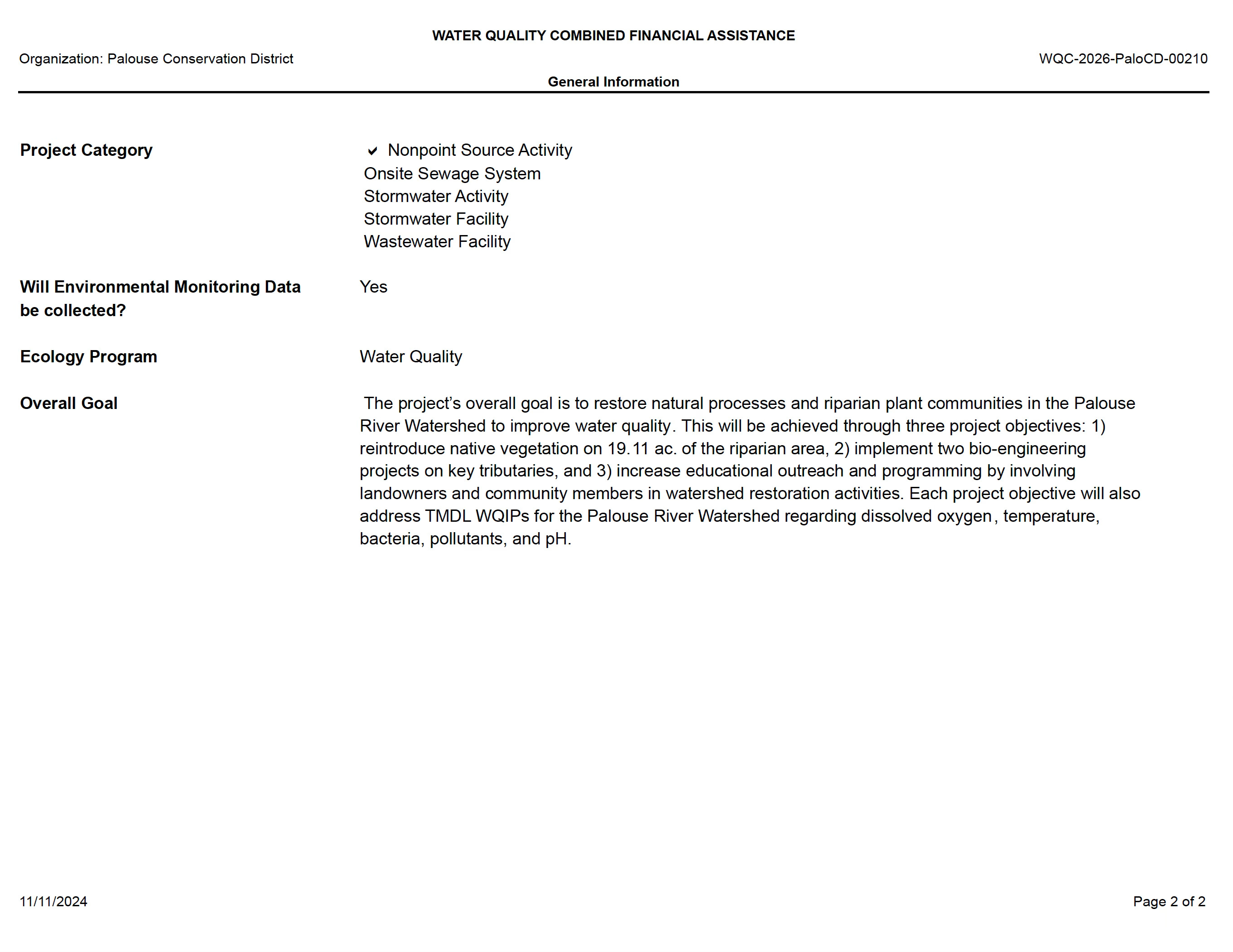
The project proposes the installation of 19.11 acres of riparian buffers and related restoration practices across multiple tributaries in the Palouse River watershed.
These activities are explicitly tied to Clean Water Act implementation and are designed to:
Address TMDL Water Quality Improvement Plans (WQIPs)
Improve temperature, dissolved oxygen, bacteria, nutrients, and pH
Contribute to watershed-scale pollutant reduction goals
Rather than relying on parcel-level pollutant measurement, the program uses standardized conservation practices—such as riparian buffers and vegetation systems—implemented across multiple sites using established design criteria.
These practices are then translated into quantifiable pollutant reductions through accepted modeling frameworks.
In other words:
Installed practices become federally reported outcomes.
This distinction is critical.
The “Methodological Bridge”
Federal programs permit modeled reductions. Direct measurement is not always required.
However, when modeled reductions are:
Derived from standardized practices
Applied across multiple sites
Reported annually as federal outcomes
Implemented within a system that also includes enforcement escalation
the relationship between field conditions, implementation decisions, and reported outcomes becomes central to program transparency.
The question is whether that relationship remains consistently documented, traceable, and aligned with Clean Water Act planning requirements.
It identifies a critical point of alignment:
whether federally reported water quality improvements—generated through modeled assumptions tied to best management practice installation—are consistently supported by documented site conditions and integrated within a clearly defined Clean Water Act planning framework.
As implementation expands across multiple watersheds, that alignment is not merely technical.
It is foundational to how federal environmental outcomes are measured, reported, and understood.
From One Creek to a Statewide Model
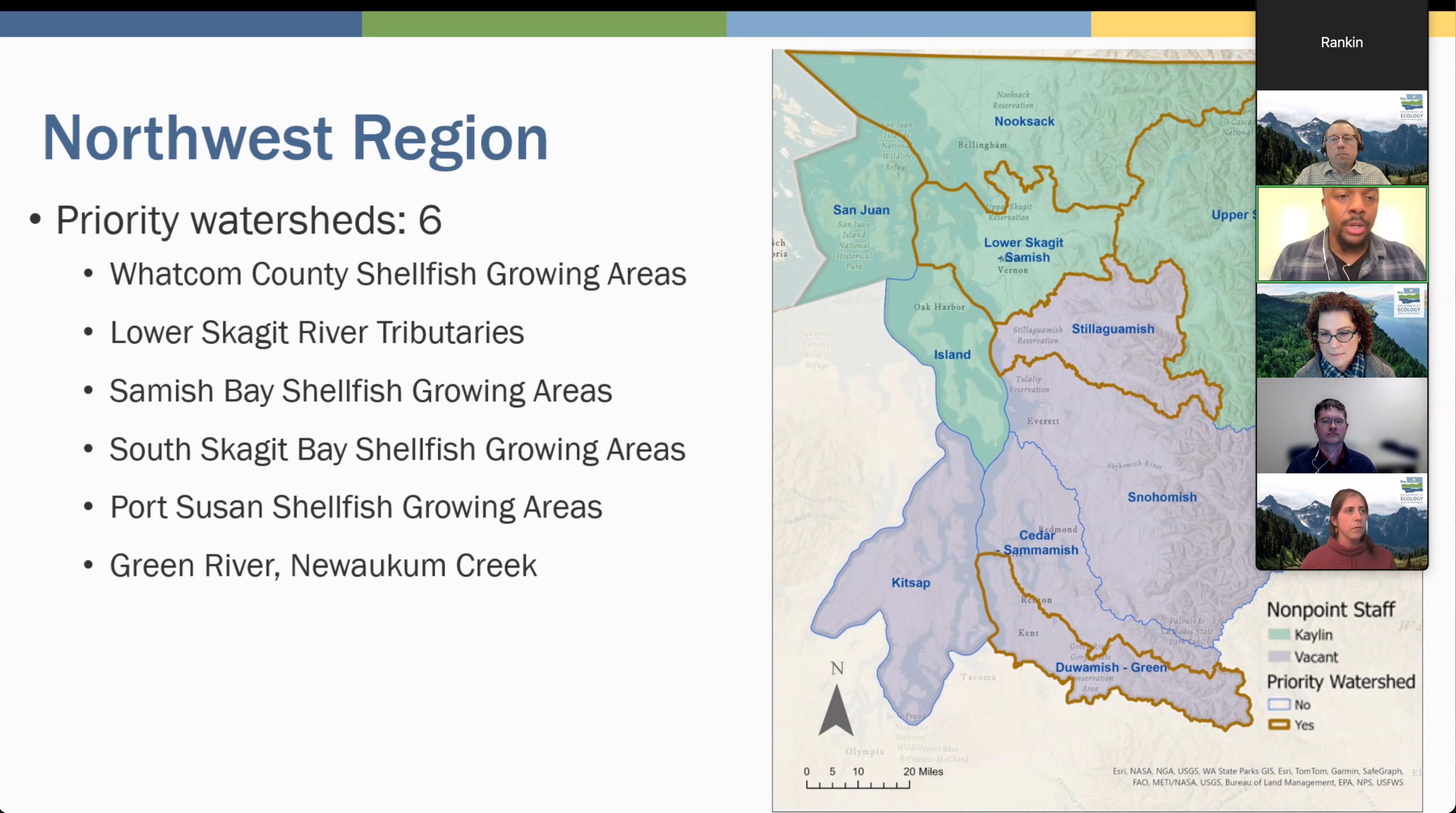
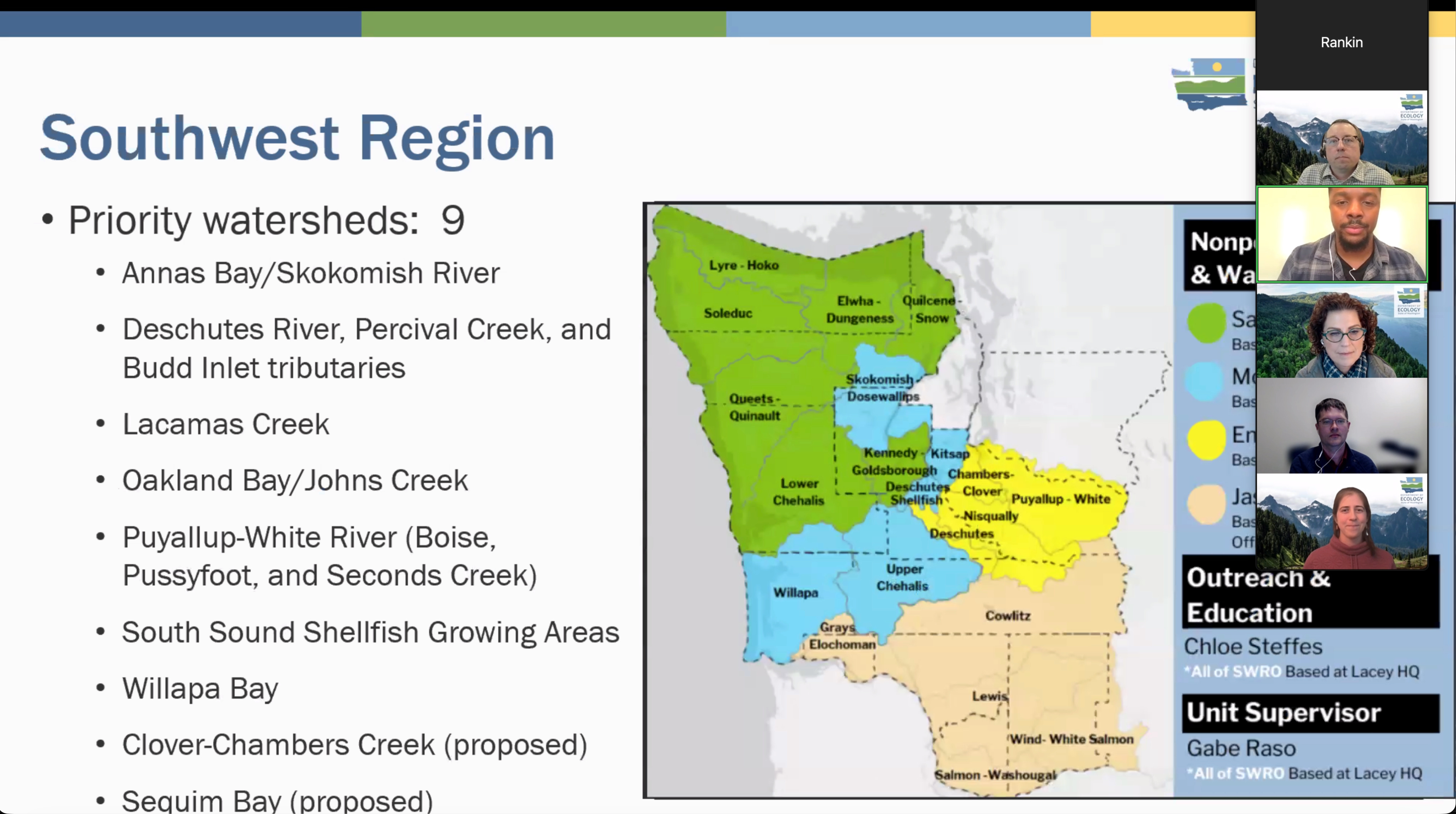
The same structure appears statewide. At the March 11 town hall, Ecology officials described a repeatable framework: identify priority watersheds, conduct field evaluations using visual tools (Livestock and Water Quality Focus Sheet and Landowner Site Assessment Tool), deliver assistance, then escalate if needed. In the Hangman watershed alone, 108 sites were engaged; five received enforcement actions.
During that meeting, Ecology described a program structure that extends beyond any single watershed—one that mirrors the structure documented in Spring Flat Creek.
Agency representatives outlined a consistent operational approach:
Identification of “priority watersheds”
Field-based watershed evaluations
Site-level identification of conditions linked to potential pollution
Delivery of technical and financial assistance
Escalation to enforcement where voluntary measures are not adopted
This description closely mirrors the structure documented in Spring Flat Creek.
In both contexts, properties are identified through watershed surveys, evaluated using similar visual criteria, and engaged through a sequence of outreach and escalation that can ultimately reference state enforcement authority under RCW 90.48.
What emerges is not a localized enforcement anomaly.
It is a repeatable implementation framework.
Spring Flat Creek is not unique in its structure.
It provides a clear, documentable example of a broader implementation model.
The consistency between field-level documentation and agency descriptions suggests that this structure is not incidental.
It is programmatic.
Watershed Identification and Property Selection
A recurring element in both the Spring Flat documentation and the March 11 meeting is the concept of properties being “identified” during watershed evaluations.
Ecology confirmed that field teams conduct watershed-level surveys to identify locations where conditions are likely to contribute to water quality impairment.
Those properties are then prioritized for outreach.
What remains less defined is the methodology behind that identification process:
Whether a standardized scoring system is used
How properties are ranked or prioritized
What data is recorded at the time of identification
How those determinations are documented and communicated
In Spring Flat Creek, letters reference underlying field data, maps, and photographs that are available upon request but not routinely provided.
The same identification language appears to be used across watersheds.
Landowners at the town hall raised this exact concern. Scott Nielsen stated:
“I think those letters, regulatory letters was the first outreach that most of the people were aware of. I don’t think you guys are doing… outreach by ecology to the ag groups locally at all.”
Mitch Redfern acknowledged the gap:
“It would have been nice if we would have done more outreach ahead of us doing some implementation work out there or mailing letters to folks… that feedback was well received… we should be doing more engagement.”
As the program expands statewide, the transparency and consistency of that identification process become increasingly relevant to both producers and oversight agencies.
Without standardized scoring or transparent prioritization, selection decisions become difficult to independently verify.
The Structural Convergence
The following convergence is documented:
Spring Flat Creek is Category 5 impaired.
TMDLs are required under federal law.
STI implementation proceeds before TMDL completion.
Enforcement letters rely on visual indicators under state authority.
Numeric buffer widths are operationalized parcel-by-parcel.
§319 funding requires annual modeled load-reduction reporting.
Federal agencies have raised jurisdictional and funding oversight concerns in related contexts.
Each component independently may be defensible.
Taken together, these elements describe a system in which federal funding, federal planning requirements, and state enforcement authority operate simultaneously—rather than sequentially—within the same watershed framework.
The intersection of all components is what warrants transparency review. As Hannah Coe, statewide nonpoint policy lead, explained during the town hall, the Nonpoint Plan update itself exists to maintain federal funding eligibility:
“The Nonpoint Plan… is required by EPA to describe how we meet Clean Water Act requirements and ensures our eligibility for that grant loan funding… Updating this plan allows us to stay eligible to receive the funding that ultimately we are then able to provide to partners and to landowners…”
Oversight in such circumstances is not adversarial.
It is procedural confirmation of alignment.
Yanasa TV has receipts for all Structural Convergence issued mentioned above.
From Enforcement to Land Status: The King Ranch Sequence
The pattern becomes tangible when viewed through a single case, the King Ranch case on Colville Reservation-adjacent trust land:
2021: Complaint from Colville Tribes → Ecology investigation begins
December 2021: Notice of Default — 14 ponds identified
October 2022: Default escalates — 14 to 18 ponds; reclassified as “critical wetlands”
January 2023: Grazing lease terminated; 12,838 acres removed from production; improvements forfeited
April 2023: Memorandum of Agreement signed for state-led restoration
2023–2025: Restoration plan repeatedly delayed
April 2025: Restoration pushed to 2027 citing budgetary constraints
2025–2026: Land reclassified as unleased, non-revenue generating, and unlikely to produce future income
2026: Nominated for Trust Land Transfer to the Confederated Tribes of the Colville Reservation (Okanogan G parcel)
The land was classified as “underperforming” following enforcement actions and lease termination.
Who These Lands Are Supposed to Serve
These are not ordinary public lands. Under the Washington Enabling Act of 1889, they are held in a fiduciary capacity for public schools and state institutions. The Washington Supreme Court has ruled the Department of Natural Resources must act with “undivided loyalty to the trust beneficiaries, to the exclusion of all other interests no matter how laudable.” The U.S. Supreme Court in Lassen v. Arizona Highway Department held that beneficiaries must receive full value and that policy goals cannot substitute for fiduciary duty.
Evolving Policy Goals and the Legal Boundary
Recent changes have expanded the Trust Land Transfer (TLT) program. HB 1460 (2023) and RCW 79.17.300 codified transfers of “underperforming” lands with high ecological or cultural value to public agencies or federally recognized tribes. The program, once limited mostly to state agencies, now includes transfers to federally recognized tribes alongside other public entities. Recent funded projects include:
Beckler 6 (676 acres) to Tulalip Tribes
Okanogan G (42 acres) to Confederated Tribes of the Colville Reservation
South Lake Ozette (372 acres) to Quileute Tribe
Tract C North (2,000+ acres) to Yakama Nation
Key Questions That Now Exist
When enforcement, implementation, and transfer converge:
Is land being rendered “underperforming” due to regulatory or administrative actions rather than market conditions?
Are full-value requirements met prior to transfer?
Are replacement lands timely and equivalent?
Are non-revenue objectives influencing decisions?
Are beneficiaries experiencing measurable financial harm?
Evidence Beyond One Case
In Clallam County, local taxing districts (schools, fire districts, healthcare providers) have documented more than $11 million in lost revenue from delayed or withheld timber sales on lands under similar fiduciary expectations. The pattern appears repeatable across systems.
Federal Jurisdiction: Why This Isn’t Just a State Issue
Federal law is directly implicated. The Clean Water Act requires TMDLs (§303(d)) and conditions §319 funding on measurable outcomes. The Enabling Act creates enforceable trust obligations, with the U.S. Attorney General authorized to act if they are not met.
EPA Region 10 and the USDA have already signaled active review of how Washington administers programs within federal boundaries. Oversight here is not intervention — it is verification of alignment.
EPA Region 10’s Regional Administrator wrote:
“Where Washington is implementing programs overseen by the EPA, we expect that you will stay within the appropriate jurisdictional bounds.”
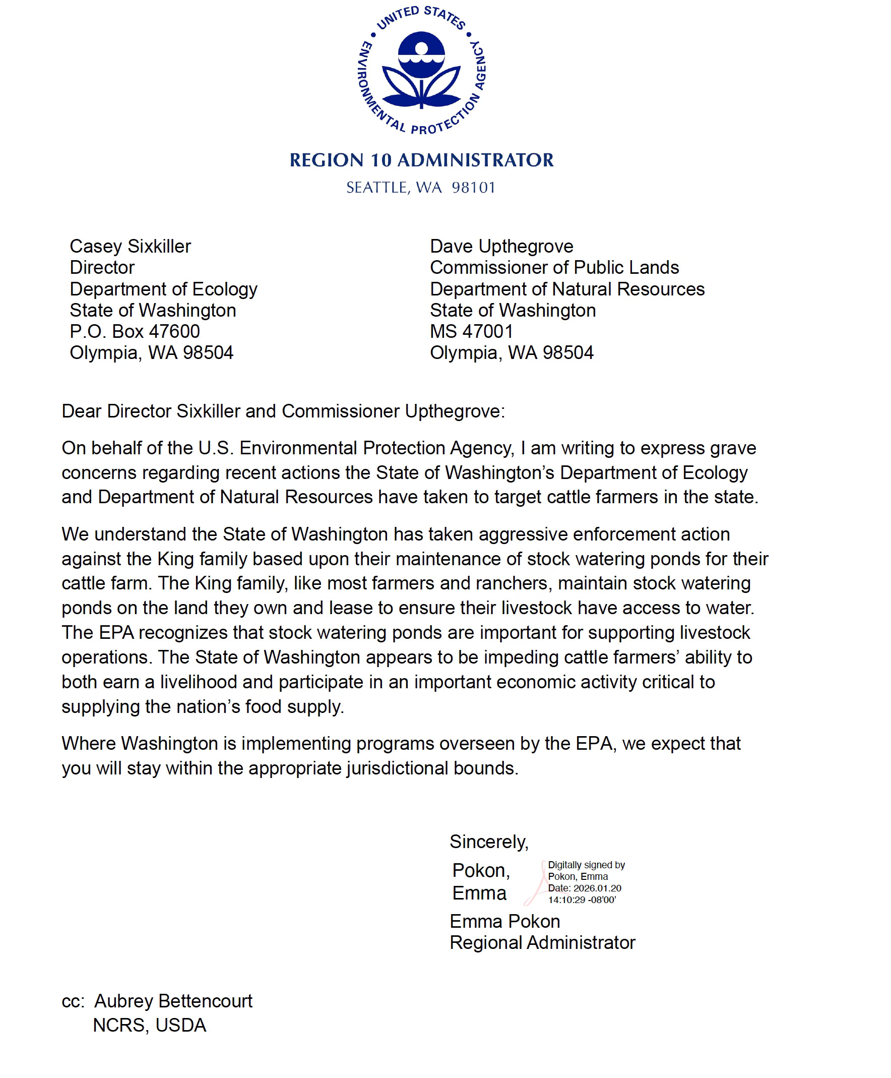
This statement does not allege violation.
It confirms that federal agencies are actively evaluating how state-level enforcement operates within federally overseen program boundaries.
Separately, the U.S. Secretary of Agriculture stated:
“USDA is reviewing funding it provides to the state of Washington and any institutions within it that may be weaponized against farmers and ranchers…”
USDA Letter to Washington State…
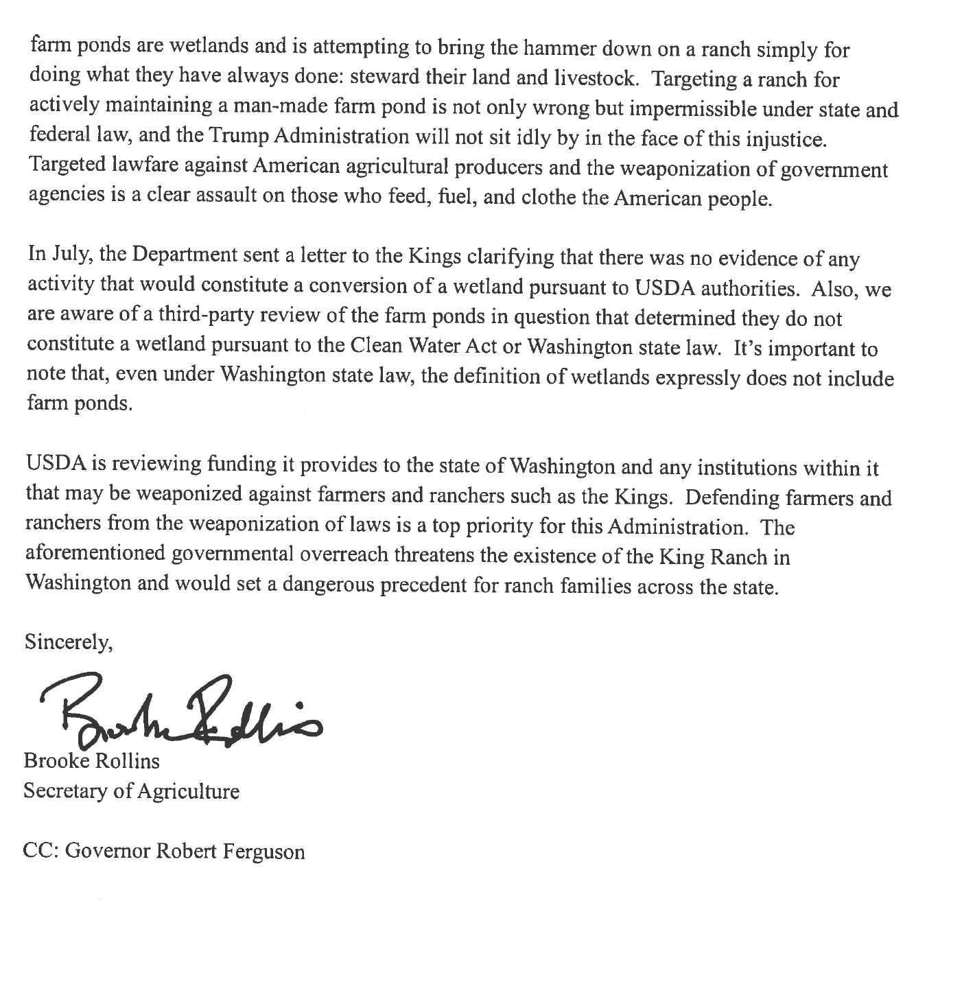
These letters concern other enforcement contexts.
But they establish a broader institutional environment:
Federal agencies are actively reviewing how Washington exercises authority within federally overseen agricultural programs.
Spring Flat Creek’s STI model integrates:
EPA-delegated Clean Water Act authority
Federally conditioned §319 funding
State enforcement under RCW 90.48
Implementation sequencing prior to completed TMDL allocation
Within that environment, alignment clarification is not speculative.
It is institutional.
What This Really Comes Down To
Each individual component is lawful; the question is whether their combined application produces outcomes that have not been fully evaluated in isolation.
This investigation does not challenge clean water goals or conservation. It examines whether the system—when federal funding, federal planning requirements, and state enforcement converge before a completed TMDL—is operating in a way that is fully aligned, documented, and transparent.
As documentation expands, the question is no longer theoretical. It is whether a repeatable implementation model is producing outcomes that remain consistent with the structure and intent of the laws that govern it.
When federal outcomes are reported based on modeled assumptions derived from site-level determinations that were never measured, the issue is no longer just about water quality.
It becomes a question of transparency, traceability, and whether the system is operating as intended.
Documentation Reviewed
Spring Flat Creek STI planning materials
Enforcement letters (Germain, Yenna, McKean) and buffer mapping
Palouse Conservation District §319 grant documents
Ecology March 2026 presentations and Voluntary Clean Water Guidance
March 11, 2026 Washington Cattlemen’s Association town hall recording/transcript
King Ranch lease and TLT nomination records
HB 1460 (2023), RCW 79.17.300, and recent TLT transfer approvals
EPA Region 10 and USDA correspondence on program oversight
Washington Supreme Court and Lassen v. Arizona Highway Department precedent
All materials are retained as part of the investigative record.