

Who Controls the Weather Now? Inside the Hidden World of Texas Cloud Seeding and the Storm That Shattered a Community
As families mourn the July 4th flood victims, questions emerge about the ethics, oversight, and unseen influence of state-run weather modification programs.


A Holiday Turned Tragic ? The July 4th Flood That Shattered Central Texas
On what should have been a joyful Independence Day celebration, a sudden and violent storm system transformed the Hill Country of Central Texas into a landscape of devastation. As fireworks illuminated the skies across the state, ominous clouds gathered above the Guadalupe River. Within hours, torrential rains unleashed a flood of historic proportions-washing away roads, homes, campsites, and countless lives.
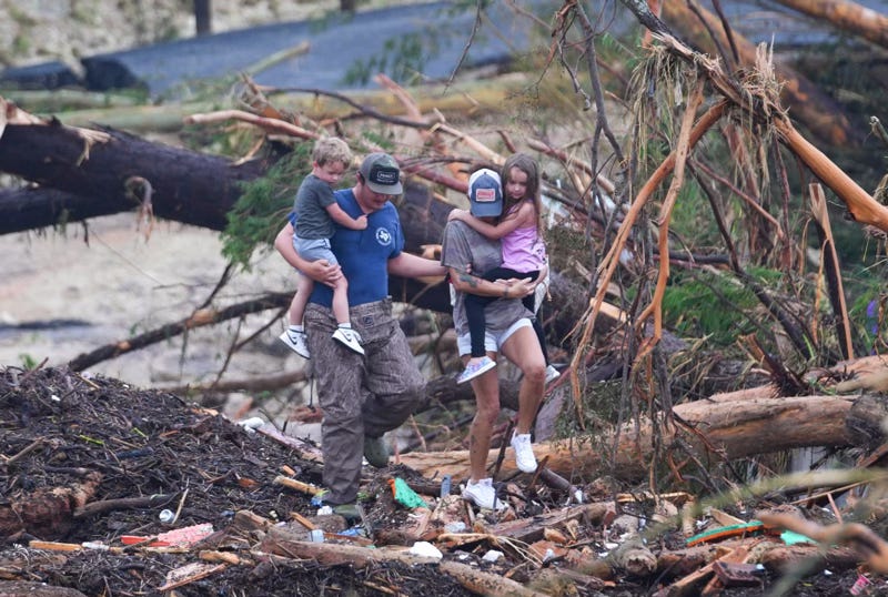
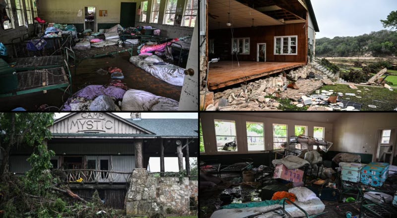
Among the hardest hit was Camp Mystic, a summer camp nestled along the river near the town of Hunt. In the dead of night, with little warning, the Guadalupe surged more than 20 feet in under two hours, tearing through the campgrounds with an unforgiving current. Dozens of young girls, many between the ages of 11 and 17, were swept into the darkness. As of this writing, at least 52 people are confirmed dead, with search teams still combing the riverbanks for those missing.
Parents, who had kissed their daughters goodbye just days earlier, now face the unimaginable task of identifying belongings pulled from the floodwaters. Some of the girls were found miles downstream. Others remain unaccounted for. Their bunkmates recall the chaos: the alarms too late, the water too fast, and the screams that vanished into the roar of the rising river.
Further downstream, an RV park near Comfort, Texas, was also devastated. Residents were jolted from their beds by emergency alerts, but many had nowhere to go. Trailers were lifted from their moorings and carried away like driftwood. First responders described the scene as “unrecognizable.” The river crested at nearly 30 feet, destroying nearly every structure along its banks.
Entire communities are grieving. Local churches have turned into command centers, morgues, and counseling shelters. Volunteers wade through mud and debris, searching for anything salvageable. In towns like Kerrville and Center Point, the flags that once waved for the Fourth now hang at half-staff.
This was not just another flash flood. This was an event of biblical scale-sudden, violent, and deeply personal. And as families mourn, and the state reels from its second-deadliest flood disaster in history, questions are beginning to rise from the murky waters: Could anything have been done to prevent it? And in our growing attempts to manage nature, have we perhaps misunderstood the consequences?
The Atmospheric Recipe Behind the July 4th Superstorm
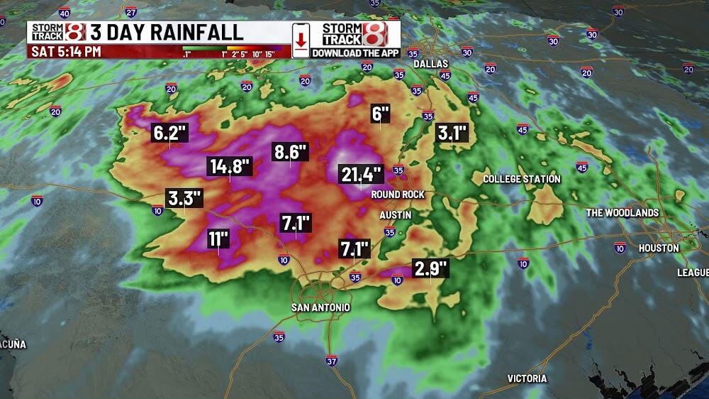
The storm that descended on Central Texas was not a random anomaly but a highly predictable-and scientifically explainable-catastrophic weather event. It formed in a deeply unstable atmosphere laden with moisture drawn from the Gulf of Mexico. Precipitable water values exceeded 2.3 inches-well above the 90th percentile for July in this region.
The trigger was a weak frontal boundary that stalled over the Hill Country, providing the lift necessary to ignite convective storms. Once initiated, these storms became quasi-stationary due to minimal upper-level steering winds. As a result, training thunderstorms dumped rainfall over the same areas for hours.
CAPE values ranged from 2,500 to 3,500 J/kg, signaling high instability, while radar indicated cloud tops exceeding 50,000 feet. The topography of the Hill Country-a landscape of steep slopes and shallow soils-accelerated runoff. Within hours, small creeks turned into torrents feeding into the Guadalupe River, which rose more than 20 feet in two hours near Hunt.
Hydrologically, this was a perfect storm: highly unstable air, slow storm movement, excessive moisture, and vulnerable terrain. The weather models flagged flood potential, but not to the historic magnitude that ultimately unfolded.
Were the Alarms Sounded in Time?
Days before the storm, the National Weather Service issued flash flood watches for Central Texas, highlighting the potential for localized heavy rainfall. However, the forecasts used cautious language, emphasizing uncertainty and variability in storm placement. The storm that struck the Guadalupe River corridor exceeded those expectations in both rainfall intensity and impact.
As the storm initiated on the evening of July 4th, real-time warnings were issued. Flash flood alerts were pushed to phones and NOAA radios. Yet, in some locations-like Camp Mystic and the RV park near Comfort-the water rose so quickly that residents had less than 15 minutes to act.
Despite advances in radar technology, forecasting the exact timing, location, and magnitude of flash flooding remains a challenge. This flood event, which developed rapidly over a small region, tested the limits of both meteorological science and public alert systems.
Texas’s Weather Modification Programs Come Under Scrutiny
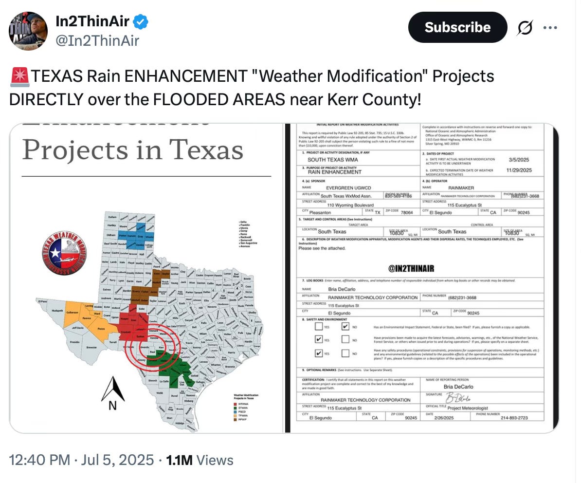
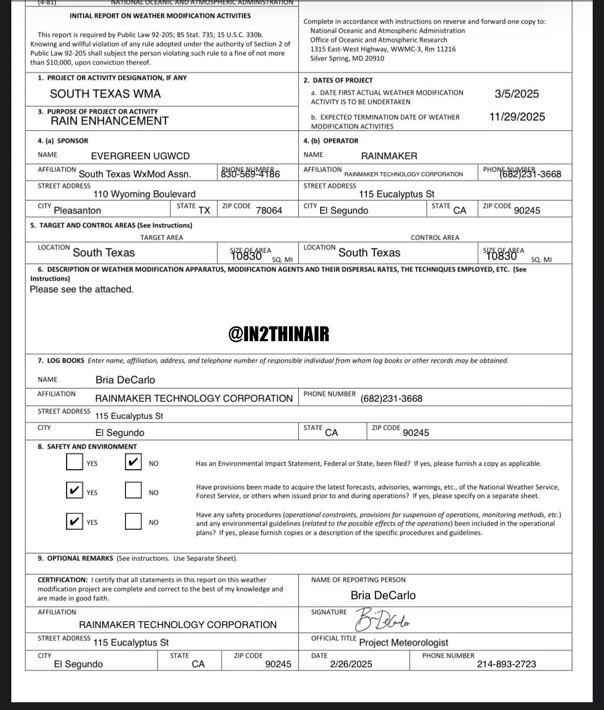
In the aftermath of the flood, speculation surged on social media. Some users pointed to a Texas company called Rain Maker, claiming it was involved in weather modification near the flood zone. While no evidence confirms this, the speculation reveals deeper concerns about the transparency of weather modification programs in the state.

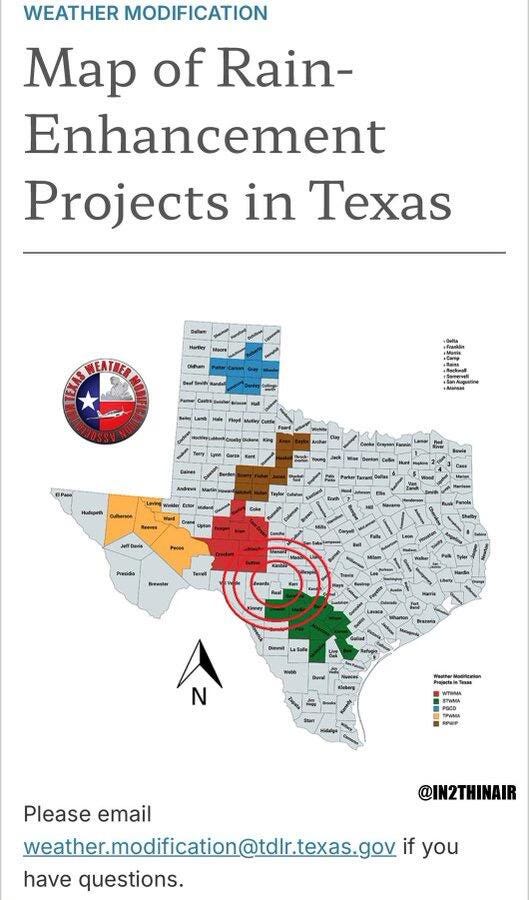
Texas is home to the largest and most coordinated cloud seeding operation in the United States. While the programs are publicly licensed and regionally managed, real-time flight data, environmental assessments, and cumulative climate impact reviews remain lacking. As water scarcity intensifies, the role of these programs—and the entities behind them—will likely face increasing scrutiny.
Public and Regional Water District Associations
West Texas Weather Modification Association (WTWMA)
Coverage: Approx. 6.4 million acres between Midland and San Angelo
Established: 1990s
Operations: Self-funded; conducts aircraft-based cloud seeding with in-house meteorologists and radar
Reported Impact: Up to 16% increase in rainfall
Website:
https://wtwma.com
South Texas Weather Modification Association (STWMA)
Coverage: Approx. 6 million acres from the Edwards Plateau to the Gulf Coast
Established: 1996
Structure: Coalition of groundwater conservation districts and counties
Operations: Year-round; uses aircraft-based silver iodide and calcium chloride dispersal
Website:
https://southtexasweathermodification.com
Panhandle Groundwater Conservation District (PGWCD)
Coverage: Approx. 4.1 million acres over the Ogallala Aquifer
Focus: Rainfall enhancement for aquifer recharge
Operations: Uses local aircraft, radar, and seeding teams
Source: https://www.tdlr.texas.gov/weather/summary.htm
Trans-Pecos Weather Modification Association (TPWMA)
Coverage: Approx. 5.1 million acres (Pecos, Ward, Reeves, Brewster Counties)
Founded: 2003
Operations: Aircraft stationed in Pecos, Fort Stockton, and Alpine
Managed By: Local irrigation districts
Source: https://www.tdlr.texas.gov/weather/summary.htm
Rolling Plains Weather Modification Project
Coverage: 3.5 million acres across North-Central Texas counties
Structure: Multi-county collaborative contracting private operators
Operation: Radar-directed aircraft seeding over small watersheds
Source: https://www.tdlr.texas.gov/weather/summary.htm
Private Contractors and Commercial Operators
• Better Weather Inc. – Littlefield, TX
Contractor for West Texas region
Provides aircraft, flare systems, and trained pilots for WTWMA and similar entities
No standalone site; mentioned in local district reports
• Plains Weather Improvement Association – Plainview, TX
Focus: Agriculture-heavy Panhandle operations
Privately operated but often under county contracts
• Atmospherics Inc. – Fresno, CA
Previously contracted by STWMA in the early 2000s
Also involved in New Mexico and Colorado
• Rain Maker (Texas)
Name frequently cited in social media discussions
No public licensing documentation available via TDLR
Possibly operates as subcontractor or under alternate name
These programs are regulated by the Texas Department of Licensing and Regulation (TDLR), which issues permits and requires post-operation reporting. However, flight logs are not made publicly accessible in real time, and public awareness of seeding operations remains low-even among residents living under seeded skies.
Program Scale (As of 2024-2025)
Total Estimated Coverage: Over 31 million acres across Texas
Program Duration: Typically March–October; STWMA often operates year-round
Technology:
Pyrotechnic flares mounted on aircraft wings
Disperses silver iodide, calcium chloride, and/or dry ice into convective clouds
Guided by ground-based radar and meteorological staff
For more on Texas programs: https://www.tdlr.texas.gov/weather/summary.htm
Examining the Hypothetical Role of Cloud Seeding and Feedback Loops
Scientific studies show that cloud seeding can increase rainfall by 10% to 30%, and in some cases even more, when conducted under optimal meteorological conditions. These include moisture-rich air masses, strong vertical updrafts, cooling cloud tops, and the presence of clouds with inefficient natural precipitation mechanisms—conditions that allow artificial nucleating agents like silver iodide or calcium chloride to accelerate droplet or ice crystal formation.
The July 4 storm in Central Texas exhibited nearly all of these ideal criteria. The atmosphere was super-saturated, with precipitable water values exceeding 2 inches—a threshold often associated with flash flooding. The system featured quasi-stationary convective cells, meaning intense storms formed and re-formed over the same narrow corridor. CAPE (Convective Available Potential Energy) values soared above 3,000 J/kg, signaling an environment primed for deep convection and explosive thunderstorm development.
In such a volatile setup, even a modest artificial boost in precipitation—on the order of 15% to 30%—could have had catastrophic consequences. For instance, if the area around Camp Mystic received 9 to 11 inches of rain, a 15% increase would have pushed totals to 10.4 to 12.7 inches. A 30% increase would have yielded 11.7 to 14.3 inches—a level of inundation that dramatically accelerates surface runoff, river stage rise, and the failure of natural drainage buffers.
Flash floods are nonlinear phenomena. Once soil saturation is reached—as it quickly is in the Hill Country’s thin, rocky soils—each additional inch of rainfall causes exponentially more water to flow across the surface. The terrain funnels this runoff into creeks and rivers that surge with terrifying speed. The Guadalupe River’s rapid rise of 20 to 30 feet in under two hours underscores how little margin for error exists during extreme weather events. The difference between a manageable flood and a deadly one may lie in just one or two inches of added rain.
When rainfall enhancement overlaps with steep terrain, shallow floodplains, and narrow watersheds—as is common across the region—the dangers compound. Excess water has no time to percolate or disperse. It cascades downslope, collecting force and volume. Under these conditions, even naturally occurring storms become life-threatening. If artificially intensified through cloud seeding, the results can be devastating.
If cloud seeding occurred in or near the impact zone—whether intentionally or as part of a routine program—it raises profound questions: Could enhanced rainfall have tipped the balance? Could a technology designed to alleviate drought have, under the wrong conditions, amplified a deadly flood?
Without full transparency—including access to real-time flight logs, seeding agent deployment records, and environmental impact disclosures—the public cannot know for certain. But what is clear is this: weather modification, even modest in scope, becomes profoundly consequential in extreme atmospheric setups. And as climate variability intensifies, so does the need to investigate whether well-meaning interventions are unintentionally escalating natural hazards.
Rain Theft? The Debate Over Downwind Deprivation
The theory of “downwind deprivation”—also referred to as “rain theft”—adds another layer of complexity. It raises a compelling question: Does artificially induced rainfall in one location deprive nearby regions of their share of natural precipitation? If atmospheric moisture is condensed prematurely through seeding and falls within a targeted area, does that reduce the amount available to areas further downwind?
This isn’t just a speculative worry—it has been the subject of debate and even litigation in regions where seeding zones intersect tribal lands, interstate river basins, or international borders. Farmers and water managers in downwind areas have claimed that nearby weather modification has led to drier conditions and decreased crop yields. Though these claims are often dismissed as anecdotal, they rest on a scientifically plausible foundation: the atmosphere is interconnected, and intervention in one region can ripple into another.
Peer-reviewed studies provide limited but suggestive evidence. A 2005 South African study reported measurable rainfall reductions downwind of seeded storm systems. A 2010 review by the World Meteorological Organizationacknowledged that while conclusive evidence is difficult to obtain, the theoretical foundation for downwind suppression is sound, especially when seeding is conducted repetitively or poorly timed.
A more recent and robust study, published in 2021 in Atmospheric Chemistry and Physics, warned that persistent cloud modification in semi-arid regions could lead to cumulative shifts in regional climate dynamics. Their modeling suggested that long-term seeding may alter:
Cloud microphysical properties, such as droplet size and precipitation efficiency
Surface humidity and boundary layer thermodynamics
Storm development pathways, particularly in already unstable or moisture-laden environments
In such scenarios, cloud seeding may not simply alter one storm—it may prolong convective activity, redirect storm tracks, or deplete downwind moisture, reshaping local hydrological cycles in ways that become significant over time.
(Study link: Atmospheric Chemistry and Physics, 2021)
The implications are profound. Cloud seeding, if it benefits one region while diminishing rainfall elsewhere, becomes a mechanism of resource redistribution—with ethical and legal consequences. Who has the right to rain? Can a groundwater district modify the atmosphere above its jurisdiction without considering neighboring communities? What if a sovereign Native American tribe experiences drought while a nearby county receives enhanced rainfall through artificial means?
These questions carry particular weight in Texas, where cloud seeding programs are active over shared river basins like the Guadalupe and Colorado, which serve not just rural counties, but also urban, agricultural, and recreational stakeholders across state lines.
Yet despite these risks, most cloud seeding programs face no requirement to assess cumulative impacts or submit cross-boundary environmental reviews. Regulations apply only to the designated seeding zone, leaving downwind effects unmonitored and unmitigated. This regulatory blind spot creates a policy vacuum—where weather is legally manipulated but not scientifically accounted for beyond its immediate impact area.
The theory of downwind deprivation remains scientifically plausible and politically relevant, even if unproven at large scales. As more regions turn to atmospheric intervention to secure water in a warming climate, the redistribution of rainfall—intentional or not—poses environmental, ethical, and geopolitical questions that demand much more scrutiny.
A Storm That Feeds the Next? The Risk of Atmospheric Feedback Loops
Perhaps the most concerning—and least studied—effect of cloud seeding is the potential for atmospheric feedback loops. In climate science, feedback loops occur when a change in one part of the system amplifies itself, leading to accelerating effects over time. While this concept is widely accepted in global climate discussions (e.g., ice melt reducing albedo, causing more warming), a growing body of research suggests similar loops could develop at a regional level through repeated weather modification.
Here’s how the loop might work in a place like the Texas Hill Country:
Cloud seeding enhances rainfall during a marginal or slow-moving storm.
This extra rainfall increases surface soil moisture and evapotranspiration, adding more humidity and latent heat to the atmosphere in the following days.
The moist, energized boundary layer contributes to the formation or intensification of future storms—which now encounter a supercharged atmosphere.
These stronger storms are then seeded again, continuing the cycle.
Each round of artificial enhancement primes the environment for the next, potentially shifting a region’s rainfall regime from sporadic and manageable to frequent, prolonged, and destructive. In landscapes already vulnerable to flooding, such as the steep, flash-flood-prone canyons of Central Texas, this cycle becomes not just a theory—but a real public safety concern.
This isn’t just hypothetical. A 2022 modeling study in Environmental Research Letters found that in semi-arid regions, cloud seeding can influence surface heating, moisture retention, and convergence zones for up to 72 hours after an event—making subsequent storm formation more likely in the same general region.
(Study link: ERL, 2022)
These findings reinforce the concern that cloud seeding doesn't just change today's storm—it may help fuel tomorrow’s.
If, for example, cloud seeding added even 1 to 2 inches of rain to an already saturated watershed on July 4, it could have accelerated the rise of the Guadalupe River, pushing it from dangerous to deadly in a matter of minutes.
Without cumulative modeling, transparent data, or public oversight, the possibility of such feedback loops remains unacknowledged in policy—and unaddressed in practice.
Denial, Dismissal, and the Chilling of Public Inquiry
In the wake of the tragedy, officials and media outlets were quick to deny any link between weather modification and the storm. Experts emphasized that cloud seeding cannot "create" storms or floods—statements that, while technically correct in a narrow sense, ignored the more nuanced question of whether seeding could exacerbate rainfall during already volatile atmospheric conditions. These immediate and sweeping denials—issued before any formal investigation or environmental review—had a chilling effect not only on scientific inquiry but on public trust.
Rather than fostering open dialogue, such blanket dismissals signal to the public that certain topics are off-limits, even when the underlying questions are rooted in observable science. Instead of saying, “We’ll look into this,” many officials said, “That’s impossible”—a stance that effectively shuts down debate before it begins.
Weather modification in Texas, despite its widespread scope, is largely unmonitored by federal environmental agencies. Programs are licensed and lightly regulated by the Texas Department of Licensing and Regulation (TDLR), but there is no comprehensive federal oversight, no requirement for cumulative impact assessments, and no formal environmental review under the National Environmental Policy Act (NEPA). Operational data—such as flight logs, cloud seeding intervals, and atmospheric injection levels—are not available to the public in real time. Citizens and journalists must rely on open records requests, many of which are delayed, heavily redacted, or denied outright.
This veil of operational secrecy stands in stark contrast to the scale and potential consequences of the programs. And when legitimate questions about unintended impacts—from rainfall enhancement to downwind deprivation—are dismissed out-of-hand as “conspiracy,” it alienates the very people who should be partners in environmental stewardship.
This pattern is not new. In other environmental and scientific controversies, we’ve seen how early defensiveness by institutions can suppress emerging truths:
The Flint Water Crisis: Officials in Michigan and at the federal level initially denied the severity of lead contamination, dismissing residents’ complaints as exaggerated. Only after whistleblowers and independent researchers intervened did the full scope of the public health disaster come to light.
PFAS Contamination: For decades, chemical manufacturers and regulatory bodies downplayed or ignored evidence that so-called "forever chemicals" were building up in water supplies and human bloodstreams. It took lawsuits and independent investigations to expose the widespread pollution.
Wildfire Smoke and Health Impacts: Until recently, health authorities often minimized the dangers of wildfire smoke, despite mounting data linking it to respiratory illness and cardiovascular risk. Early guidance encouraged people to "stay indoors" rather than push for air filtration, evacuation, or systemic change.
Lab Leak Hypothesis (COVID-19): In the early months of the pandemic, the suggestion that SARS-CoV-2 might have originated from a laboratory was immediately branded as misinformation, despite some virologists calling for inquiry. Only later did international agencies and governments acknowledge that the origin question remained unresolved and worth investigating.
In each of these cases, early institutional defensiveness delayed accountability and eroded public trust. Worse, it sometimes gave the appearance that science was being used not as a tool for discovery, but as a shield for liability.
When it comes to weather modification, the stakes are no different. If programs meant to increase rainfall under drought conditions can, under extreme setups, intensify storms, that deserves investigation—not deflection. And if our understanding of regional atmospheric systems is still evolving, then humility—not certainty—should guide the response.
Real science thrives in environments where questions are encouraged, not suppressed. Public institutions should not fear inquiry; they should welcome it, especially when lives are at stake. In an era of climate instability, when extreme weather can turn deadly in hours, the public deserves answers grounded in transparent science—not talking points.
Cloud Seeding and the Silent Thirst of Texas Data Centers
Cloud seeding has long been justified as a drought mitigation strategy—aimed at replenishing aquifers, supporting agriculture, and sustaining municipal water supplies. But as Texas becomes a national hub for high-tech infrastructure, a new and largely unspoken beneficiary has emerged: data centers.
Texas is now home to hundreds of data centers, with major facilities operated by Amazon, Google, Microsoft, Meta, and Oracle. These centers support cloud computing, artificial intelligence, cryptocurrency mining, and massive-scale digital services. While their energy consumption is often scrutinized, their water use is less visible—but just as significant.
How Much Water Do Data Centers Use?
Modern data centers rely heavily on evaporative cooling systems, which can consume millions of gallons of water per day to prevent overheating. According to public filings:
A single hyperscale facility (like those operated by Meta or Microsoft) may use 300,000 to 1 million gallons daily.
Some centers in Central Texas draw water directly from municipal supplies or rural aquifers, often competing with nearby farms and residents.
In dry years, data centers have been known to purchase water rights or rely on emergency contracts from nearby utilities.
This thirst is projected to grow. As artificial intelligence systems scale up—and as cryptocurrency mining intensifies in rural Texas—water becomes not just an operational resource, but a strategic asset.
Enter Cloud Seeding
This is where cloud seeding quietly enters the equation. While these programs are promoted as benefiting agriculture and aquifer recharge, they can also indirectly support the water needs of data centers:
Increased Rainfall = Higher Reservoir and Aquifer Levels
Seeding-induced rainfall helps replenish surface water bodies and underground aquifers. In regions like Hays, Williamson, and Travis counties—where data centers are proliferating—rain-enhanced recharge can increase availability for industrial use.More Water for Utilities = Less Pressure on Restrictions
When rainfall boosts water supply, municipal and utility providers have more flexibility to meet both residential and commercial demand—including the massive draw from data centers. In some regions, this allows them to delay or avoid drought restrictions that might otherwise limit industrial use.Strategic Placement of Seeding Operations
Some critics argue that certain weather modification programs appear to target upstream watersheds that feed into reservoirs near high-tech hubs. While not explicitly designed for corporate benefit, the spillover effectsundeniably benefit any user connected to those systems—including major cloud infrastructure firms.Avoiding Public Scrutiny
Because cloud seeding is framed as an agricultural or environmental tool, it often escapes scrutiny in conversations about Big Tech's water footprint. Yet the interdependence is real: more seeded rain means more surface water, which can ultimately sustain corporate expansion in already water-stressed regions.
The I-35 Tech Corridor
Between Austin and San Antonio, where the STWMA (South Texas Weather Modification Association) operates, cloud seeding flights frequently target storms along key aquifer recharge zones. These same zones feed water systems that support massive tech campuses and data centers. Companies like Tesla, Meta, and Amazon Web Services have established or are building facilities here—each with their own water footprint. Though there's no public record linking these companies to seeding programs, the geographic overlap is significant.
This raises a deeper question: Should a public weather modification program—funded by taxpayers or groundwater districts—be indirectly subsidizing the water needs of some of the wealthiest corporations in the world? And if so, where is the environmental review or public consent?
While agriculture remains a primary “justification” for cloud seeding in Texas, the expanding role of water-intensive tech infrastructure demands a broader conversation. As cloud seeding shapes precipitation patterns, it also shapes who gets to benefit from water—and who does not.
If future rain is to be engineered, the public must ask: For whom is it being engineered?
Who Owns the Weather, and Who Gets to Change It?
Weather modification forces us to confront uncomfortable moral questions: who gets to decide when and where it rains? Who takes responsibility when interventions go wrong? And what rights do ordinary people have to the sky over their heads?
Cloud seeding often occurs without public consultation or real-time notification. Affected communities-like those living downstream of seeding zones-are rarely given a voice. This violates fundamental principles of consent and environmental justice.
As the climate grows more volatile, the temptation to engineer atmospheric outcomes will increase. But without ethics, transparency, and accountability, we risk turning shared weather into private power.
Reclaiming the Sky – Toward Accountability in a Modified Atmosphere
The July 4th flood was a natural disaster, at least reported in theory. But it also marks a pivotal moment in the public conversation around weather modification. Whether or not cloud seeding played a role, the tragedy exposed how little the public knows about who is modifying the weather, how often, and why.
It’s time to demand full transparency, real-time reporting, and independent environmental review of all weather modification activities. It’s time for lawmakers to bring these programs into the light-and for communities to reclaim their right to know what’s happening in the sky above them.
Let this not be just a tragedy remembered, but a turning point acted upon.
Scientific Studies and Academic References
Atmospheric Chemistry and Physics (2021) – Persistent Cloud Seeding Effects
https://doi.org/10.5194/acp-2021-122Environmental Research Letters (2022) – Cloud Seeding Feedbacks in Semi-Arid Regions
https://iopscience.iop.org/article/10.1088/1748-9326/ac5e36World Meteorological Organization – WMO Expert Reports on Weather Modification
https://library.wmo.int/doc_num.php?explnum_id=10668South African Study on Downwind Deprivation (2005)
https://journals.co.za/doi/10.10520/EJC97589
Texas Weather Modification Programs and Regulatory Oversight
Texas Department of Licensing and Regulation (TDLR) – Weather Modification Program Overview
https://www.tdlr.texas.gov/weather/summary.htmTDLR Weather Modification Rules and Permit Info
https://www.tdlr.texas.gov/weather/weathermod.htmWest Texas Weather Modification Association (WTWMA)
South Texas Weather Modification Association (STWMA)
https://southtexasweathermodification.com
Additional Context and Supporting Articles
Texas Public Radio – “Does Cloud Seeding Really Work?”
https://www.tpr.org/environment/2022-08-22/does-cloud-seeding-really-work-texas-has-tried-it-for-decadesTexas Monthly – “Rainmakers” (2015)
https://www.texasmonthly.com/news-politics/rainmakersNational Geographic – “What is Cloud Seeding?”
https://www.nationalgeographic.com/environment/article/cloud-seedingScientific American – “Can Humans Control the Weather?”
https://www.scientificamerican.com/article/can-humans-control-the-weather
Flooding and Weather Event Data (Texas, July 4, 2025)
National Weather Service – Austin/San Antonio Office: Event Archive
https://www.weather.gov/ewx/US Geological Survey (USGS) Stream Gauge Data – Guadalupe River
https://waterdata.usgs.gov/nwis/uv?site_no=08167500NOAA Storm Prediction Center – Convective Outlooks and Reports
https://www.spc.noaa.gov